
|
|
 |
County Down is one of the nine counties in the Province of Ulster in the North of Ireland. Renowned for its world famous scenery, it is rich in prehistoric remains, and the ruins of medieval castles and monasteries dot the landscape. Our 100km Down Sundial Trail starts in Bangor in the north, a popular seaside resort with a pier and marina, and ends in Newcastle in the south of the county 'where the mountains of Mourne sweep down to the sea'. The National Trust maintains seven historic villages/homes/gardens here and of course Down has its sundials.
The Bangor Monastery Dial
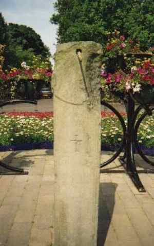 In the Rose Garden in front of Bangor Town
Hall (formerly Bangor Castle - built 1847) there is an ancient vertical stone
dial 1500mm high 300mm wide by 200mm thick dated circa 900 A.D. Originally
located in Bangor Monastery, of which nothing remains, it was relocated to the
Castle over 100 years ago. Only five timelines of a possible twelve remain on
the damaged 'U' shaped head and nothing remains of the gnomon but the hole in
the slab where a wooden or metal gnomon would have fitted. Three crosses are
carved on the stele.
In the Rose Garden in front of Bangor Town
Hall (formerly Bangor Castle - built 1847) there is an ancient vertical stone
dial 1500mm high 300mm wide by 200mm thick dated circa 900 A.D. Originally
located in Bangor Monastery, of which nothing remains, it was relocated to the
Castle over 100 years ago. Only five timelines of a possible twelve remain on
the damaged 'U' shaped head and nothing remains of the gnomon but the hole in
the slab where a wooden or metal gnomon would have fitted. Three crosses are
carved on the stele.
British Sundial Society SR
Noiety Register No 4219
Lat 54° 40' Long 5° 40'
Irish Grid J
350 53 .
38235
The Bangor Abbey Dial
 Next stop is but a few short steps to the
North Down
Heritage Centre in the Town Hall grounds where you can see a fine model of
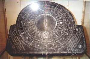
what the ancient monastery might have looked like. On display here is a John
Bonar sun, moon and tide slate dial, 400mm by 350mm by 15m thick, dated
1630. Originally designed for Bangor Abbey Church on the site of the ancient
monastery, it too was removed to the Castle over 100 years ago.
Next stop is but a few short steps to the
North Down
Heritage Centre in the Town Hall grounds where you can see a fine model of
what the ancient monastery might have looked like. On display here is a John
Bonar sun, moon and tide slate dial, 400mm by 350mm by 15m thick, dated
1630. Originally designed for Bangor Abbey Church on the site of the ancient
monastery, it too was removed to the Castle over 100 years ago.
This is
an equatorial dial which means that it should be set up at an angle parallel to
the equator so that the summer sun shines on the upper face and in winter on
the lower face, which is also elaborately carved. It had movable arms one of
which was fitted with weights, like an astrolabe, and could be turned until the
moon appeared in the eye-piece. This eliminated the need for a shadow, and the
dial could have been used whenever the moon was visible. The dial also has a
wind rose, with the name of a port opposite each point of the compass. The
compass bearing is what is called the 'port establishment', which very roughly
gives the direction of the moon at the high tide for the particular harbour.
Ayr, London, Bristol, Dublin and Cork are among the thirty places featured. The
dial is covered with mottos and verses in Latin and Scots.
One of only four
known by this early 1600's Ayr school teacher, another is in the archives of
the Drumfries Museum, Scotland.
Photo Copyright North Down Heritage Centre and M.J.Harley ©
2001
Lat 54° 40' Long 5° 40'
Irish Grid J
35053 .
38235
The Mount Stewart Dial
 Leave Bangor on the A20 heading south 10km
to Newtownards. Go through Newtownards, stay on the A20, head southeast towards
Portaferry on the Ards Penninsula. After 8km you arrive at Mount Stewart House,
a
National Trust property on the shore of Strangford Lough.
An 18th century ancestral home and one of the greatest gardens in the country,
it is well worth a visit in its own right. But located in the Lily Garden is
the object of our visit, a circular brass dial 200mm in diameter mounted on a
1200mm high pillar. The inscription reads
Leave Bangor on the A20 heading south 10km
to Newtownards. Go through Newtownards, stay on the A20, head southeast towards
Portaferry on the Ards Penninsula. After 8km you arrive at Mount Stewart House,
a
National Trust property on the shore of Strangford Lough.
An 18th century ancestral home and one of the greatest gardens in the country,
it is well worth a visit in its own right. But located in the Lily Garden is
the object of our visit, a circular brass dial 200mm in diameter mounted on a
1200mm high pillar. The inscription reads
Serene I
stand among the flowers
And only count life's sunny hours
For me dark
days do not exist
I'm a brazen faced old optimist
British Sundial Society SR NoietyRegister No 3608
Lat
54° 33' Long 5° 36'
Irish Grid J
35527 .
36951
The Nendrum Dial
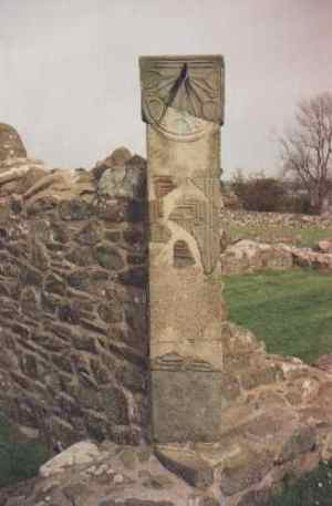 Return to Newtownards and this time take
the A21 to Comber 9kms. Leave Comber on the A22 road to Killyleagh, turn-off
1kms south of Comber to Nendrum Monastery, a further 8km. Located on Mahee
Island in Strangford Lough, it is accessed by narrow bendy roads and a
causeway. Founded in the 5th century, the remains of a round tower, stone
enclosures and a church are still to be seen. Here you will find a vertical
stone dial 1900mm high 400mm wide by 150mm thick dated circa 900 A.D., the same
period as the Bangor Dial. It was reconstructed from pieces found during
excavation in 1924. There is a visitor centre on site.
Return to Newtownards and this time take
the A21 to Comber 9kms. Leave Comber on the A22 road to Killyleagh, turn-off
1kms south of Comber to Nendrum Monastery, a further 8km. Located on Mahee
Island in Strangford Lough, it is accessed by narrow bendy roads and a
causeway. Founded in the 5th century, the remains of a round tower, stone
enclosures and a church are still to be seen. Here you will find a vertical
stone dial 1900mm high 400mm wide by 150mm thick dated circa 900 A.D., the same
period as the Bangor Dial. It was reconstructed from pieces found during
excavation in 1924. There is a visitor centre on site.
British Sundial Society
SR NoietyRegister No 3614
Lat
54° 30' Long 5° 38'
Irish Grid J 35330 .
36387
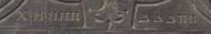
The Corbally Dial
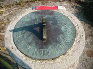
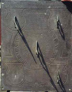 Return to the A22 and continue south 24kms,
passing through Balloo and Killyleagh to Downpatrick. Located on the Mall,
Down County Museum (once
Downpatrick Gaol) has some restored cells and houses exhibits on the history of
Down. The museum has eight slate dials, some of them damaged, in it's archives
(not on display). The photo shows one of these, an unusual horizontal dial,
490mm by 395mm wide, The smaller of the two central dials is delineated for
Jerusalem and the main dial is for Corbally 5km east of Banbridge. There is an
eight point windrose at the base of the gnomon. The four subsidiary dials, one
at each corner of the plate are for Savanna, Calcutta, Botany and New York. The
Botany gnomon is missing, the others are bent. Made for a Jas. Murry in 1834 by
J. McNally. The quotations are in Latin and English, "I shew by the kindnefs
& splendour of the sun" " Sol gloria sphira" "Life in it's greatest vigour
is altogether vanity" "Brevis huminum vita" There is a Places - Lat - Long
table between Jas Murry - J McNally names, for the five locations delineated.
The method of showing the date is unusual in that it uses the ancient Greek
numbering system used in monumental Athenian inscriptions of the 1st
Millenium B.C.
Return to the A22 and continue south 24kms,
passing through Balloo and Killyleagh to Downpatrick. Located on the Mall,
Down County Museum (once
Downpatrick Gaol) has some restored cells and houses exhibits on the history of
Down. The museum has eight slate dials, some of them damaged, in it's archives
(not on display). The photo shows one of these, an unusual horizontal dial,
490mm by 395mm wide, The smaller of the two central dials is delineated for
Jerusalem and the main dial is for Corbally 5km east of Banbridge. There is an
eight point windrose at the base of the gnomon. The four subsidiary dials, one
at each corner of the plate are for Savanna, Calcutta, Botany and New York. The
Botany gnomon is missing, the others are bent. Made for a Jas. Murry in 1834 by
J. McNally. The quotations are in Latin and English, "I shew by the kindnefs
& splendour of the sun" " Sol gloria sphira" "Life in it's greatest vigour
is altogether vanity" "Brevis huminum vita" There is a Places - Lat - Long
table between Jas Murry - J McNally names, for the five locations delineated.
The method of showing the date is unusual in that it uses the ancient Greek
numbering system used in monumental Athenian inscriptions of the 1st
Millenium B.C.
![]()
There is another McNally
dial in the museum but one of the corner subsidiary dials is broken off and
missing. Anyone wishing to view these dials must phone ahead first to enquire
if it is possible. 028 4461 5218
Photo Copyright Down County Museum and M.J.Harley ©
2001
Lat 54° 20' Long 5° 44'
Irish Grid J
34742 .
33726
The Tollymore Dial
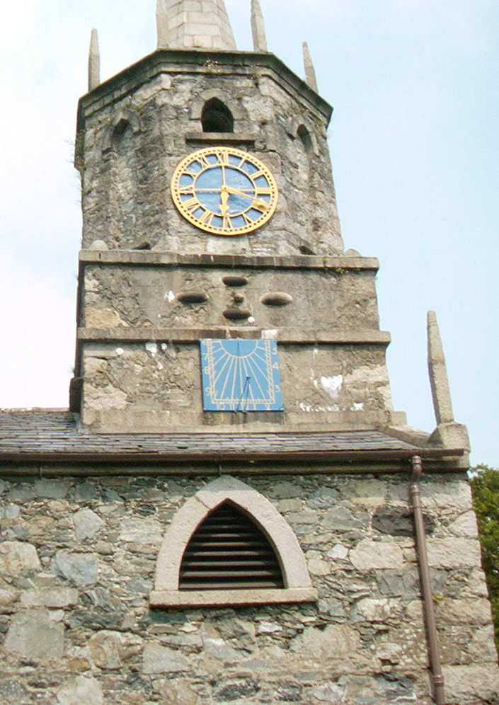 Leave Downpatrick on the A25 heading for
Newcastle. Travel south west 20km (through Clough where you make a right turn),
to Castlewellan. Leave Castlewellan on the A50 for 1km then take the B180 to
Bryansford and follow the road sign to Tollymore Forest Park 3km. The first
national park in the British Isles, it covers an area of 500 hectares at the
foot of the Mourne Mountains. At the entrance to the park high up on the
octagonal belfry tower of Clanbrassill barn is a painted vertical stone dial
700mm high by 600mm wide. The barn was built by Lord Clanbrassill c.1760 and
the clock and bell are dated 1785.
Leave Downpatrick on the A25 heading for
Newcastle. Travel south west 20km (through Clough where you make a right turn),
to Castlewellan. Leave Castlewellan on the A50 for 1km then take the B180 to
Bryansford and follow the road sign to Tollymore Forest Park 3km. The first
national park in the British Isles, it covers an area of 500 hectares at the
foot of the Mourne Mountains. At the entrance to the park high up on the
octagonal belfry tower of Clanbrassill barn is a painted vertical stone dial
700mm high by 600mm wide. The barn was built by Lord Clanbrassill c.1760 and
the clock and bell are dated 1785.
British Sundial Society
SR NoietyRegister No 3616
Lat
54° 13' Long 5° 58'
Irish Grid J
33262 .
33167
Here our trail ends..but not quite.
When you return
to our starting point in Bangor take the A2 heading west towards Belfast for
about 5kms and you will come to
Ulster Folk &
Transport Museum at Cultra. This open air museum has a typical Ulster town
of 100 years ago, farms, cottages, livestock, award winning railway collection
and a TITANIC exhibition.
Yes - they do have sundials but they are not on
display yet. Maybe someday soon ...
Lat 54°39' Long
5° 47'
Irish
Grid J
34306 .
38025
 |